

Our area is known for excellent snowmobiling!
Have guarantied fun in this fascinating harsh winter scenery of the Rocky Mountains! Or go for the alpine fun, to groomed and maintained trails. Beautiful alpine areas wait for the experienced and the first time rider! Ask us for a Tour arrangement !
We strongly recommend a guided tour for first time sledders! This is the fun and less risky way to explore the high alpine country! Have a fabulous time and stay safe!
Choose From 4 Different Groomed Trails
Allan Creek Trail
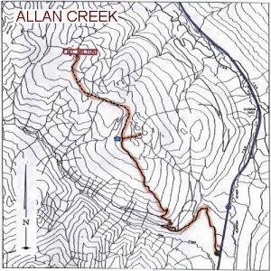
Allen Creek Trail Map
The Allan Creek trail is one of the easiest areas to ride, although it can be difficult in new snow conditions.
The trailhead parking lot is just off Highway 5, 35km south of Valemount. The trail system uses a Forest Service Road (often not snow cleared) and old trails to gain access to the alpine area. Watch for “No Snomobiling” signs to the west of Premier Range.
Chappell Creek (Miledge Creek) Trail
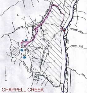
Chappell Creek Trail Map
The alpine area is located 25 km from the parking lot. The trail is located to the west of Highway 5 , 45 km south of Valemount.
The trail system partially uses Forest Service Roads, fire and skid trails to access alpine areas at the headwaters of Chappell Creek. The combination of weather to this area (heavy snowfall, winds, low clouds…) and rugged terrain create dangerous conditions. Cornices regularly develop on the leeward side of ridges. Sledders should be prepared for white outs and conditions conducive to avalanches. First time users should always go with others well familiar with the trail system.
Also a major concern in the winter time are the Mountain Caribou. Difficult snow conditions, low forage add up to poor physical conditions of the animals. Do not pursue or otherwise harass the wildlife! If you sight them move quietly away, going about 1 km before resuming normal activity.
Keep in mind that mountain caribou studies will be in process this winter. These snowmobiling areas are being monitored for caribou use and conflicts with snowmobiling.
The Allan Creek trail is one of the easiest areas to ride, although it can be difficult in new snow conditions.
The trailhead parking lot is just off Highway 5, 35km south of Valemount. The trail system uses a Forest Service Road (often not snow cleared) and old trails to gain access to the alpine area. Watch for “No Snomobiling” signs to the west of Premier Range.
Clemina Creek

Clemina Creek Trail Map
Your first access trail to the alpine area is left up Morning Glory trail at 15 km. At the 19km warm-up-cabin, the Windtunnel trail to the left also provides alpine access. At 21 km the valley trail swings left to access Goat Ridge Bowl.
These trails provide good access to the alpine area for average riders, except in new snow conditions. In this case you should have the company of experienced mountain riders! Sledding from one alpine area to another is possible but should not be attempted without help from sleddders, that know snow conditions and area very well. It is very easy to get into Danger Basin and not be able to get out either end without towing your machine by hand . Danger basin should only be explored under good snow conditions by experienced sledders. And you should be sure of being able to return by the entry route used .
Cautions: There are no avalanche hazard forecasts available for this area!. The meadow trail will bypass several avalanche paths and turn onto Goat Ridge Trail at the start of Avalanche Valley. These avalanche paths and the whole of Avalanche Valley are extremely dangerous and you should avoid them. Entering Goat Ridge Bowl, Danger Basin and Lakeview is generally sled by way of Meadow Trail and Goat Ridge Trail.
The Allan Creek trail is one of the easiest areas to ride, although it can be difficult in new snow conditions.
The trailhead parking lot is just off Highway 5, 35km south of Valemount. The trail system uses a Forest Service Road (often not snow cleared) and old trails to gain access to the alpine area. Watch for “No Snomobiling” signs to the west of Premier Range.
West Ridge Trail
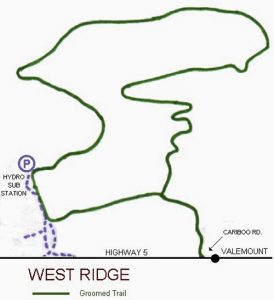
West Ridge Trail Map
Please note that the ridge and the alpine areas above the trail are closed to snowmobiling. The annual Snowarama of the Timberline Snow Goers Club is held on this trail because of its suitability for riders of every age and experience.
The Allan Creek trail is one of the easiest areas to ride, although it can be difficult in new snow conditions.
The trailhead parking lot is just off Highway 5, 35km south of Valemount. The trail system uses a Forest Service Road (often not snow cleared) and old trails to gain access to the alpine area. Watch for “No Snomobiling” signs to the west of Premier Range.
